Nareen, once known as Bilston's Springs, is a dairying district north of Coleraine in south-west Victoria, Australia. (Ref: "Place names of Victoria", Les Blake).
History of Nareen and Tarrayoukyan
The following brief history is an extract from the local history publication "History of Nareen and Tarrayoukyan 1836-1970" by Ewan F Neeson.
Exploration by Major Thomas MITCHELL, Nareen & the Surrounding Areas in 1836
The Nareen district is an area, the boundaries of which would be very hard to define. Suffice to say that it would include portions of the parishes of Tarrayoukyan, Brim Brim, Dewrang, Brimboal, Koolomert and Moree.
The early pastoral leases that would be included or surround this area would have been the Kout Narin run later divided into Mooree, Koolomurt, Chetwynd and Wellat runs which were more or less a partnership, and Springvale, Wando Dale, Satimer and Steepbank.
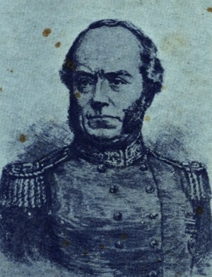 Major Thomas MITCHELL
Major Mitchell in his epic journey of exploration through the area which he named Australia Felix passed through the north westerly portion of the Nareen district, and this was the first known appearance of the white man in this country.
The party consisted of Major Thomas Mitchell, who was Surveyor General for New South Wales, his second in command Granville Chetwynd Stapylton, Alexander Burnett, overseer; Robert Muirhead, soldier; five bullock drivers; two blacksmiths, three horse carters; one medical attendant, John Roach, a collector of birds; John Richardson, collector of plants; two sailors; a shepherd; a groom; two carpenters; a shoemaker and a cook. Also there was the aboriginal Piper who was the interpreter. All, except Mitchell, Stapylton and Piper were convicts or ex-convicts. All were dressed in grey trousers and red shirts, and wearing crossed white braces, their dress resembling the military garb of the day.
This large party was travelling with vehicles too heavy for the wet conditions of the country and it was through these parts that they encountered the greatest troubles, the extremely boggy ground and wet weather slowed their progress to less than half the distance they had been accustomed to travel. The vehicles included two carriages with the whaleboat and several drays all drawn by bullocks.
According to Mitchell's writing and Stapylton's diary, copies of which are held by the writer, the party crossed the Glenelg River some distance east of where Harrow stands now, then they travelled through country of open forest land consisting of a few gum trees, honeysuckle and she-oak. Having camped on a stream on 2nd August, the following day travelling in a south westerly direction they came at length to a valley almost two miles in width, and at the junction of a similar valley two streams joined. As they reached the spot a bronze winged pigeon flew up and as this was the first one Mitchell had seen south of the Grampians, he called the stream Pigeon Ponds, they camped there that night.
They crossed this stream, apparently about where another from the south entered it - through the property Burthong of today, and the following day encountered very boggy conditions, only covering four miles, breaking many chains, ring bolts and also poles. They reached another stream and encamped there on the night of 4th August. Mitchell decided to call this Granville, but altered it to the Chetwynd, they both being Stapylton's christian names.
On the 5th they decided to halt for the day as the heavy vehicles had not caught up and the conditions were having adverse effects upon the bullock teams. Stapylton was ordered to trace the Chetwynnd to its junction with the Glenelg, there he marked a tree on a small knoll with his pen knife. Stapylton states the distance from the Glenelg to the camp was ten miles, but Mitchell states nine, of course this was not a chained distance as was their main route, it was simply calculated by the time of the journey.
Aborigines were sited near the camp, but seemed to be surprised by the arrival of the white men and could not be induced to speak with the aboriginal Piper as had most of the natives previously encountered.
A temporary bridqe of logs was made across the Chetwynd and on the morning of the 6th August they continued their journey. This crossing of the Chetwynwd was effected according to the map of the journey at the junction of a creek with it in Allotment 33, parish of Koolomert just east of the present bridge at Tite's Hill.
On the 6th they continued in a south westerly direction for almost four miles until they came to a swampy area, actually the headwaters of the Steep Bank Rivulet, this was extremely boggy and combined teams had to be used to draw each vehicle through it; they camped that night just west of the swamp.
The following day, the 7th, they progressed even less favourably, and Mitchell rode on some miles to find a firmer terrain, at about five miles he discovered the hilly country between what is Major's Creek and the Glenelg. He returned to his camp and spent all the 8th travelling less than a mile, but having reached the firmer ground the followinq day, they passed out of the area with which we are concerned.
- 1842 Area Sketch Map
- Map showing Pastoral Runs of this area
- Casterton & District Historical Society
Harrow Cemetery Headstones (external link)- Major Mitchell in the Dartmoor area
- SS 1893 Koolomert
Tarrayoukyan Cemetery Headstones (external link)