Links to many of the main pages and lists on this Glenelg & Wannon Pioneers website.
Contributions of articles, stories, website links, etc., relating to the history and individuals or families of the south-west corner of Victoria, Australia will be gratefully received and acknowledged. Please email Daryl with any corrections or additional information : Daryl Povey.
Map: South West Victoria (1842 sketch map) - shows squatters, inns and tracks only 5 years after the HENTY family moved inland to settle "Merino Downs", "Muntham" & "Sandford".
Map: South West Victoria (Counties) - 1885 map showing Counties of Lowan, Borung, Follett, Dundas, Normanby & Villiers from Lake Hindmarsh in the north to Portland & Warrnambool on the south coast.
Map: Western Victorian Modern Map (zoom in / out) (ext. link)
Map: Google Maps (Modern Map, Seach for locations, etc) (ext. link)
Pioneer Families & Individuals at ...
Articles
-
1834+ : The HENTY Family & Early Settlement
1836 : Extract from the Diary of Major Mitchell, August, 1836 (Dartmoor & Nelson)
1837+ : Settlement at "Muntham" (E. Henty)
1837+ : Settlement at "Merino Downs" (F. Henty)
1837+ : Pastoral Runs (maps & occupiers)
1840+ : John George ROBERTSON settled at Wando Vale
1840+ : Wando Vale Squatters & Selectors, 1875 Ratepayers
1840+ : Merino Township Settlers
1840+ : Merino District Settlers
1845+ : Jas. MALLETT at Muntham
1846 : Death of Alexander McKINLAY at Strathdownie
1848 : James HAMILTON, "Ozenkadnook Station" to Portland by Bullock Dray
1849+ : Rev. Francis Thomas Cusack RUSSELL 1823-1876 ; "Parsonage on the Wannon"
1849-1942 Henry Cowland, Dartmoor & Greenwald
1853 : Letter from John Norman McLEOD, "Tahara" Pastoral Run
1856+ : Cuthbert Fetherstonhaugh at Muntham
1857 : James BONWICK, Inspector of Schools - North from Portland on Horseback
1850s : O'BREE Family, Carapook, Muntham & Natimuk
1862+ : St Andrews Presbyterian Church, Coleraine
1863 : Henry BEST - Tragic Death at Sandford
1863-1963 Glenelg Shire Councillors
1865 : Land Leases Carapook & Muntham area 1865 : Land Leases Tahara & Grassdale area 1865 : Robert LINTON - Importing sheep from England to Western Victoria
1865+ : "Holy Trinity" Anglican Church, Coleraine ; Rev. Francis Thomas Cusack RUSSELL 1823-1876; "Parsonage on the Wannon"
1866-1978 : Drik Drik Church History
1873 : Drowning of Malcolm McLean of "West Ardno" at Casterton
1874 : Dr Lovell Byass 1811 - 1874
1884 : Jubilee Speech by Francis Henty
1886-1920 : West Wimmera Mail & Natimuk & Goroke Advertiser newspaper extracts
1887 : J. S. Anderson's Oak Tree at Sandford
1900 : Wando Vale Closer Settlement Scheme (successful applicants)
1902 : John Hughes, stonemason 1815-1902
1910 : Death of Mrs John BLAY (Elizabeth FOGARTY) 1817-1910
1915-19 : Major Norman McDONALD, Carapook and WW1
1919 : Spanish Flu in South-western Victoria
c1920 : Glenorchy Estate (Merino) Soldier Settlement Scheme
c1920 : Paschendale (Merino) Soldier Settlement Scheme
Foxhunt at Corndale, near Casterton
Floods & Fires in the Casterton Area
Photographs
-
The Vern McCallum Photo Collection
external link to website by Geoff Corner providing a sample of the huge collection by Vern McCallum of historical photographs of south western Victoria.
Picture Australia
external link to a large searchable database of Australian photographs. Try searching for a town or location, family name or topic. You may be surprised.
Australian War Memorial Photograph Database
external link to a collection of over 200,000 photographs which is searchable by name, location, etc. Worth a look, you may be surprised.
Cemeteries
-
Ian Marr's S-W Victorian Cemetery Headstones
An external link to website by Ian Marr providing headstone details from a growing number of cemeteries in south-western Victoria. This page is no longer active. If you know of a new site please contact the Webmaster.
Military History
-
Crimean War, American Civil War & Anglo-Boer War Veterans from the Casterton District
Major Norman McDonald, Carapook, Egypt & ANZAC
Booroopki Avenue of Honour WW1
Carapook Honour Rolls WW1 & WW2
Casterton War Memorial - WW1 Deaths
Chetwynd School Honour Rolls WW1 & WW2
Coleraine & District WW1 Service involvement, 1916
Dartmoor Avenue of Honour
Dartmoor Honour Rolls
Dergholm Memorial Hall WW1 Honour Roll
Dergholm Memorial Hall WW2 Honour Roll
Digby WW1 Avenue of Honour
Digby WW1 Honour Roll No.1
Digby WW1 Honour Roll No.2
Digby WW2 Honour Roll
Drik Drik Honour Rolls
Greenwald Avenue of Honour
Henty SS 2020 WW1 Honour Roll
Hotspur WW1 Avenue of Honour
Hotspur School Honour Roll
Merino War Memorial WW1 & WW2
Muntham WW1 Honour Roll
Muntham WW1 Honour Roll
Sandford War Memorial WW1 & WW2
Sandford WW1 School Honour Roll
Sandford WW2 School Honour Roll
Sandford WW1 St Mary's Church Honour Roll
Sandford WW1 Sons of Temperance Honour Roll
Strathdownie Honour Rolls
Wando Vale District Military Service
South West Victoria's War History 1899-1999
It is back on-line! An external link to a website by Deakin University containing a large database of many of the names from military Honour Rolls in south western Victoria. (Nov 2006)
This page is no longer active. If you know of a new page please contact the Webmaster. Australian War Memorial
external link to this Australian website with excellent databases on War Deaths, Nominal Rolls, Images, Decorations, books, records & more ...
Commonwealth War Graves Commission
external link with excellent information on the location of graves (where known) of soldiers from all Commonwealth Countries. May have some next of kin information. "Their Name Liveth for Evermore"
Newspaper Extracts
-
West Wimmera Mail extracts 1886-1920
A growing list of extracts by Daryl Crabtree from the Goroke, Natimuk, Noradjuha areas in the county of Lowan, West Wimmera
Schools & Schooling
Branxholme Area Schools
Branxholme SS 1978Byaduk Area Schools
Byaduk SS 855Byaduk North SS 1418
Casterton Area Schools
Bahgallah SS 1586Carapook SS 1624 & SS 1969 & Bruk Bruk SS 915
Muntham School SS 2112
Casterton SS 2058
Casterton High School
Chetwynd SS 2738
Chetwynd East SS 2975
Chetwynd Junction SS 1777
Corndale SS 2716
Derghom SS 1729
Dunrobin SS 3777
Lake Mundi SS 1786
Langkoop / Meereek SS 2633
Nangeela SS 3037
Poolaijelo SS 2978
Power's Creek SS 2217
Roseneath SS 1730
Tallangower SS 1871
Tullich SS 2604
Wytwarrone SS 2273
Coleraine Area Schools
Bil-Bil-Wyt SS No 1936Brit Brit SS No 1332
Coleraine SS No 2118
Gringegalgona SS No 4349
Gritjurk SS No 1041
Gritjurk South SS No 3326
Hilgay SS No 4281
Konongwootong SS No 1338
Konongwootong SS No 3769
Balochile or Konongwootong South SS No 3789
Konongwootong North SS No 4362
Melville Forest SS No 4415
Muntham SS No 2112
Salt Pans SS No 1041
Tarrayoukyan SS No 1688
Wootong Vale SS No 4478
Condah Area Schools
Condah South SS 3055Dartmoor Area Schools
Dartmoor SS 1035Dartmoor North SS 3148
Drik Drik SS 971
Greenwald SS 2653
Greenwald East SS 4559
Lyons SS 3254
Mumbannar SS 1354
Nelson SS 1615
Puralka SS 4584
Digby Area Schools
Digby 191 & SS 2047Digby South SS 2876
Morven SS 3826
Hotspur Area Schools
Hotspur SS 1260Lower Crawford SS 2406
Macarthur Area Schools
Ardonachie Common SchoolMerino Area Schools
Bowtell's Creek SS 2601Glenorchy Estate SS 4351
Grassdale SS 1547
Henty & Dwyer's Creek SS 2020
Merino SS 2115
Merino Downs SS 2548
Mocamboro SS 1448
Murndal SS 1735
Paschendale SS 4107
Tahara SS 1378
Tahara Bridge SS 2451
Tahara West SS 3493
Talisker SS 4492
Wurt Wurt Koort SS 3728
Sandford Area Schools
Sandford SS 1654Strathdownie Area Schools
Ardno West SS 2974Kaladbro SS 2397
Killara SS 2378
Killara North SS 3425
Strathdownie SS 2883
Strathdownie West SS 2239
Wilkin (Strathdownie East) SS 2359
Wando Vale Area Schools
Brimboal SS 2023Wando Vale SS 3397
Wando Vale North SS 3591
Wando Bridge SS 3842
Wando Heights SS 4668
Area Maps
-
Casterton (Henty Street) Plan, 1882
Dartmoor Area Map
Digby Town Plan (1800s)
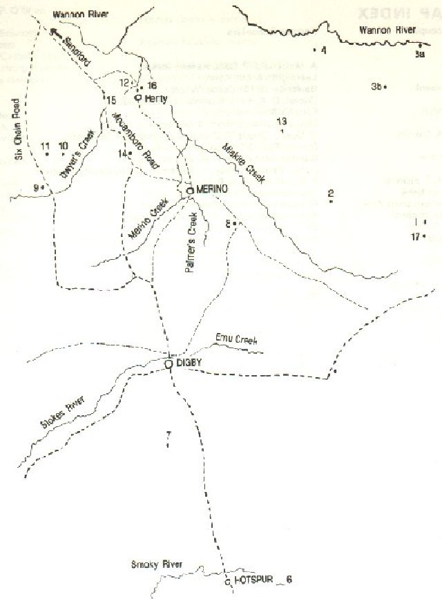
Hotspur to Sandford sketchmap
Pastoral Runs around Casterton, 1830's - 1880's
Pastoral Runs around Digby, Hotspur & Dartmoor, 1830's - 1880's
Sandford Township Map
South Western Victoria (1842)
South Western Victoria (1990s)
County Maps - South Western Victoria (ca1885)
-
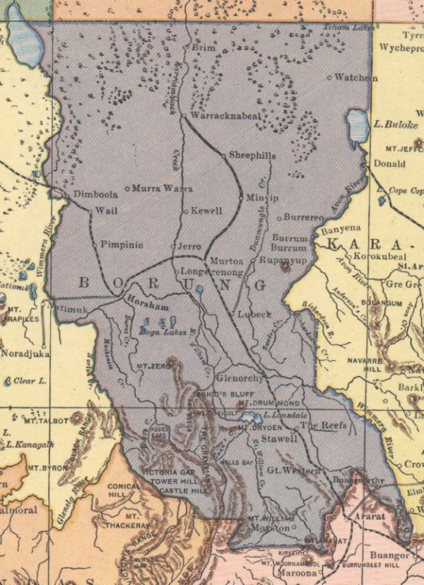
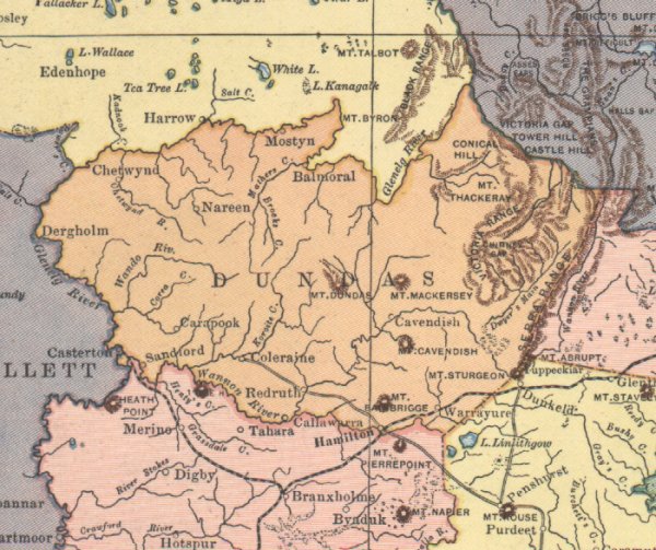
Counties of South Western Victoria - 1885 map showing Counties of Lowan, Borung, Follett, Dundas, Normanby & Villiers from Lake Hindmarsh in the north to Portland & Warrnambool on the south coast
Borung - Horsham, Stawell
Dundas - North of Hamilton
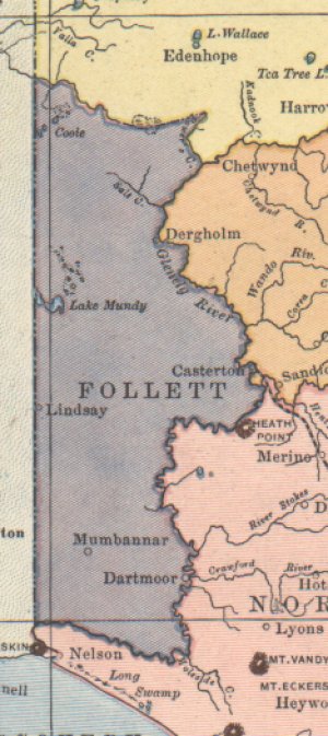
Follett - West of Casterton
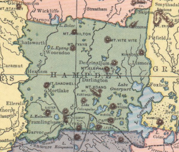
Hampden - Mortlake, Camperdown
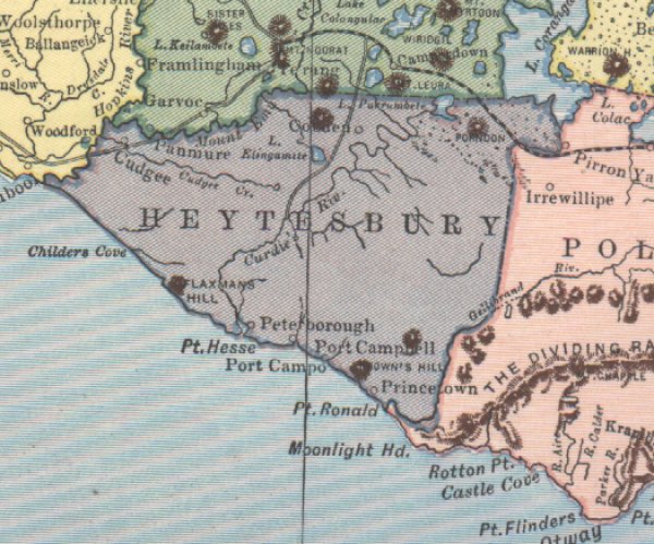
Heytesbury - South of Camperdown
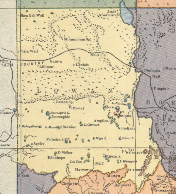
Lowan -West of Horsham
Normanby - Portland & North to Hamilton
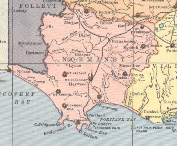
Ripon - Ararat
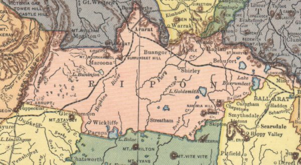
Villiers - Warrnambool, Port Fairy & North to Dunkeld
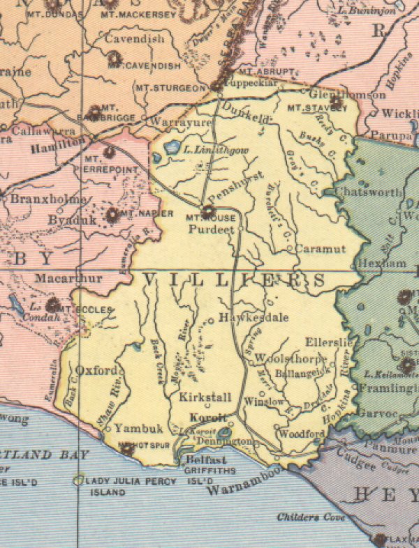
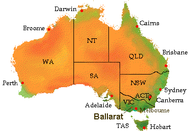
Maps around Ballarat & other Areas of Victoria - north east of the Portland area